IP2Location IP-Country-Region-City-Latitude-Longitude-TimeZone-NetSpeed Database
View Sample Data
The IP address range covered by this demo is limited to a small range in the commercial database.
Download IPv4 / Download IPv6Request Free Sample
Request free sample database and source codes for PHP, ASP.NET, ASP, C#, VB.NET, Microsoft SQL, and MySQL.
| Features | Translates IP address (IPv4 or IPv6) to country, region or state, city, latitude and longitude, time zone, and net speed. |
|---|---|
| Current Version | 2024-07-15 |
| Update Frequency | Semi-monthly |
| Database Format |
Binary (BIN)
ASCII Text File (CSV) |
| IPv4 Database Size |
BIN:
364.11 MB CSV: 1.29 GB (11,882,670 Rows) |
| IPv6 Database Size |
BIN:
452.68 MB CSV: 1.73 GB (13,980,764 Rows) |
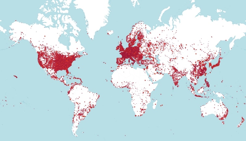
| Total Cities | >110,000 (Coverage Map | Data Accuracy) |
| Name | Type | Description |
|---|---|---|
| ip_from | INT(10) / Decimal(39,0) | First IP address in netblock. |
| ip_to | INT(10) / Decimal(39,0) | Last IP address in netblock. |
| country_code | CHAR(2) | Two-character country code based on ISO 3166. |
| country_name | VARCHAR(64) | Country name based on ISO 3166. |
| region_name | VARCHAR(128) | Region or state name. |
| city_name | VARCHAR(128) | City name. |
| latitude | DOUBLE | City latitude. Defaults to capital city latitude if city is unknown. |
| longitude | DOUBLE | City longitude. Defaults to capital city longitude if city is unknown. |
| time_zone | VARCHAR(8) | UTC time zone (with DST supported). |
| net_speed | VARCHAR(8) | Internet connection type. DIAL = dial up, DSL = broadband/cable/fiber/mobile, COMP = corporate, T1 = data center/transit, SAT = satellite |
| Name | Description |
|---|---|
| Continent Multilingual | Continent names in multiple languages. |
| Country Multilingual | Country names in multiple languages. |
| Country Flags | Countries flag icon in multiple sizes. |
| World SVG Map | World border shape in SVG format. |
| ISO 3166-2 Subdivision Code | ISO 3166-2 codes for the names of countries and their subdivisions. |
| Country Information | Additional country information, such as capital, total area and so on. |
| Region Multilingual | Region names in multiple languages. |
| City Multilingual | City names in multiple languages. |
| Olson TimeZone | Olson TimeZone value for cities. |

1. Retrieve
Retrieve the IP address from the networking protocol or server-side variable of web server.

2. Convert
Convert the IP address to an IP number in decimal format to speed up the database query.

3. Pinpoint
Reverse lookup the IP number using geolocation database to pinpoint the exact geographical location.
License Agreement: General Terms and Conditions for the database licensing.
Server License: Comparison of Standard License, Site License and Redistribution License.
IP2Location™ and IP2Proxy™ are registered trademarks of HEXASOFT. All other trademarks are the properties of their respective owners.
- How to install and use IP2Trace on Linux for traceroute
- Importing IP2Location data into Oracle Database and querying with PHP (IPv6)
- Integrating IP2Location C Library With Go Programming Language
- How to automate downloading, unzipping & loading of IP2Location DB24 data into Linux MySQL
- Importing IP2Location data into MongoDB and querying with PHP (IPv6)
- Determine Web Visitors Country of Origin in the Drop Down List using PHP and MySQL Database
Worldwide Coverage Map